Sardinia has no shortage of places that look almost unreal on a phone screen: granite coves filled with turquoise water, medieval walls glowing at sunset and archaeological sites hidden inside mountains. But the island’s most photogenic locations are not necessarily the easiest to reach. Cala Coticcio now has regulated access, Tiscali requires a substantial hike, and several famous beaches are best photographed outside the crowded middle of the day. For creators, the useful question is not simply “where is the Instagram spot?” but how to visit it without damaging the landscape or discovering too late that access is controlled.
There is also one common naming mistake worth correcting. Cala Coticcio on Caprera is often compared visually with Tahiti, but the Sardinian beach officially and widely known as “Tahiti” is Cala Brandinchi near San Teodoro. Both belong on a photography itinerary, but they are different places in different protected landscapes.
Cala Coticcio, Caprera: the granite-and-turquoise shot
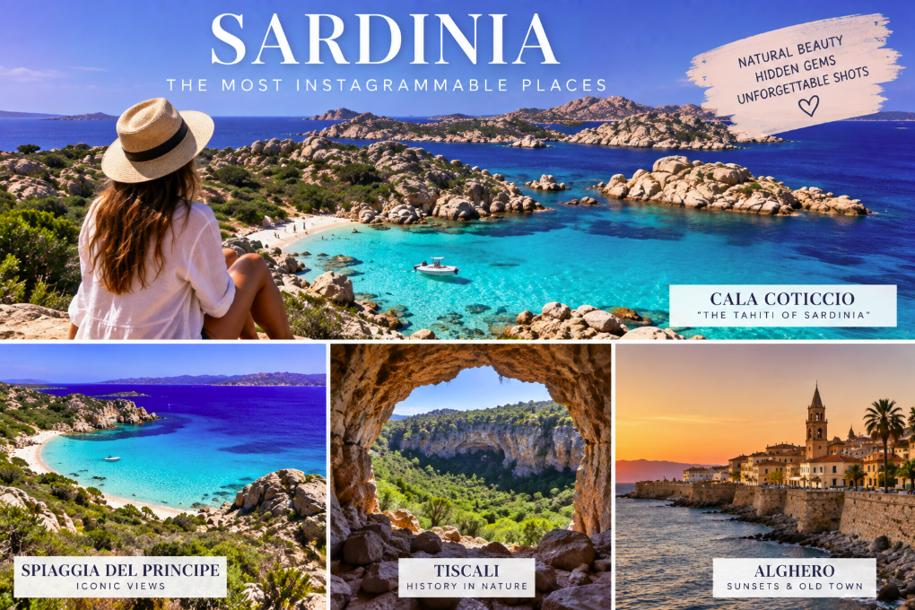
Cala Coticcio is one of the signature images of the La Maddalena Archipelago: pale granite rocks, Mediterranean scrub and intensely clear water on the eastern side of Caprera. The visual appeal comes partly from scale. It is a small, delicate cove rather than an enormous beach, which makes the granite formations feel almost wrapped around the water.
In 2026, however, this is not a place to treat as a spontaneous Instagram stop. The La Maddalena National Park classifies the Cala Coticcio trail as a TA zone of significant natural interest requiring a high level of protection. It is not freely accessible. Visitors can reach it with an authorized environmental hiking guide, and the Park currently requires a €3 contribution per visitor in addition to the price agreed with the private guide.
The Park strengthened access monitoring again in May 2026, with daily control and surveillance along the Cala Coticcio and Cala Brigantina trails. Guides have also been using a new online authorization process since June 2026, including submission of participant names.
For photographers, this means booking first and building the shoot around the guided visit rather than expecting unlimited time at the cove. It also means keeping drones out of the plan unless a qualifying operation has received the required authorization: La Maddalena National Park has strict drone restrictions.
Spiaggia del Principe: the classic Costa Smeralda frame
If one beach captures the visual language of Costa Smeralda, Spiaggia del Principe is a strong candidate. The official Sardinia tourism portal describes an arc of white sand inside a deep inlet, protected by pink granite and surrounded by the greens of Mediterranean vegetation and turquoise-to-blue water.
The beach is associated with Prince Karim Aga Khan IV, whose development vision helped shape Costa Smeralda from the 1960s. Despite the luxury mythology surrounding the coast, Spiaggia del Principe itself is a public beach and is reached on foot after leaving the road and parking area.
For photographs, the most useful compositions are not necessarily taken at water level. The approach offers opportunities to include the curve of the bay, granite and different bands of sea color in the same frame. Early morning is preferable if the goal is a cleaner beach scene; by peak summer midday, the human reality may look very different from an empty promotional photograph.
Tiscali: Sardinia’s most unexpected archaeological photograph
Tiscali is the opposite of a roadside viewpoint. Hidden inside Monte Tiscali between the Supramonte of Oliena and Dorgali, the archaeological settlement occupies a huge natural depression in the mountain. SardegnaTurismo describes remains of two groups of dwellings built along the walls of the cavity, with a broad natural opening looking toward the Lanaittu valley.
The setting is what makes Tiscali extraordinary for photography: stone ruins, holm oaks and Mediterranean vegetation exist inside what feels like a hidden chamber in the mountain. It is archaeology and landscape in a single frame.
Reaching it requires effort. The regional tourism portal describes roughly two hours of demanding trekking to reach the depression, and admission to the archaeological area is paid. Footwear, water, heat and daylight matter more here than camera gear.
A wide lens works well for showing the scale of the cavity, but photographers should resist climbing ruins or leaving the established route for a better angle. The archaeological site is the subject, not a prop.
Cala Brandinchi: the beach actually nicknamed “Tahiti”
Cala Brandinchi, in the Capo Coda Cavallo area near San Teodoro, is the beach that SardegnaTurismo explicitly identifies as being known as Tahiti. Its almost white sand, shallow turquoise water and view toward Tavolara explain the nickname.
It is also one of Sardinia’s most popular beaches, particularly with international visitors. During the controlled summer season, access arrangements can include advance booking and visitor limits, so travelers should check the current San Teodoro beach-booking system before setting out.
The classic image places the pale shallows in the foreground and Tavolara on the horizon. Calm mornings usually produce cleaner reflections and less disturbed water, while midday sun intensifies the turquoise color but also brings the strongest crowds and harshest light.
Alghero’s walls at sunset
Not every Sardinian photo needs turquoise water. Alghero offers one of the island’s strongest urban sunset compositions, especially from the historic sea walls and bastions. Warm sandstone, old rooftops and the western horizon make the city particularly photogenic in the final hour of daylight.
The advantage for creators is accessibility. Unlike Tiscali or Cala Coticcio, the old town can be explored slowly on foot, and the visual story continues after sunset with narrow streets, restaurant terraces and illuminated historic buildings.
For a recognizable Alghero image without turning the shoot into a checklist, use the walls as foreground and let the sea and Capo Caccia direction provide the horizon. The atmosphere is often stronger than a tightly framed monument shot.
Capo Caccia: cliffs rather than beach umbrellas
North-west of Alghero, Capo Caccia provides a completely different Sardinian scale. High limestone cliffs drop into deep blue water, with viewpoints around the promontory and the famous descent toward Neptune’s Grotto.
The Escala del Cabirol staircase contains 654 steps, so the location rewards travelers willing to move rather than simply park at a beach. Sea conditions and weather can affect access to the grotto and staircase, which should be checked before the journey.
Late-afternoon light can be dramatic on the cliffs, but wind is an important practical factor. Keep loose equipment secure and do not step beyond barriers for a wider frame.
Tharros and the Sinis Peninsula
At Tharros, ancient ruins meet the sea on the Sinis Peninsula near Cabras. Columns and archaeological remains are often photographed against the blue water, but the broader landscape is equally important: the site sits between the Gulf of Oristano and the open western coast.
It is one of the strongest places in Sardinia for combining cultural content with a coastal image. Unlike a beach-only photograph, a Tharros frame immediately communicates that the island’s appeal is also archaeological.
The site is exposed, with limited shade, so summer photographers should plan for heat. Morning or later-afternoon light is generally more comfortable and gives the stone more texture.
Castelsardo: the hill-town panorama
For the classic photograph of a Sardinian town rising above the sea, Castelsardo is difficult to beat. The medieval center climbs a rocky promontory on the island’s north coast, with tightly packed houses below the castle.
The best-known compositions are often made from outside the historic center rather than inside it, because distance allows the entire promontory and town profile to fit into the scene. Once inside, switch from panorama to details: stairways, stone alleys, doors and views between buildings.
Golfo di Orosei: the view from the water
Cala Goloritzé, Cala Mariolu and the limestone coast of the Gulf of Orosei generate some of Sardinia’s most recognizable travel images. But this coast is also a reminder that a photograph can hide the logistics. Beaches may require long hikes or boat access, and environmental rules differ by location.
Cala Goloritzé is particularly protected and access is regulated. Visitors should verify the current reservation system rather than assuming that a viral photograph means unrestricted access.
For a broader visual story, photographing the cliffs and coves from a boat can be more effective than collecting close-ups of every famous beach. It also reveals the enormous vertical scale of the Supramonte coastline.
Piscinas: Sardinia without turquoise clichés
The dunes of Piscinas on the Costa Verde are among the island’s most distinctive landscapes. Here the visual palette changes to gold sand, Mediterranean vegetation and an open western sea. The lack of dense coastal construction in the immediate landscape gives photographs an unusually expansive quality.
Sunrise and late afternoon create long shadows across the dunes, revealing their shape better than flat midday light. The dunes are a fragile ecosystem, so marked access routes and environmental restrictions should be respected rather than treating every ridge as a photo platform.
The best Sardinia photo is often the one without a crowd
Instagram has a tendency to compress Sardinia into a few famous turquoise coves. The island is more interesting photographically when the itinerary mixes those icons with mountains, archaeological sites, old towns and the western coast.
Timing matters as much as location. July and August can transform a supposedly empty cove into a busy beach within an hour. May, June, September and early October often offer more flexibility, although weather and seasonal services vary.
Creators should also separate photography access from drone access. Being legally allowed to walk onto a beach does not mean a drone can be launched there. Italy’s D-Flight geographical zones and any protected-area rules must be checked separately before flying.
Most importantly, do not damage the place to reproduce somebody else’s photograph. Cala Coticcio’s guided-access rules, Tiscali’s archaeological protections and visitor controls at sensitive beaches exist because the most photographed landscapes are often the ones under the greatest pressure.
Sardinia’s strongest images still come from the same ingredients that made these places famous: unusual geology, clear Mediterranean light and landscapes where nature remains dominant. Photograph them well, but leave enough space in the itinerary to find a view that does not already have a million versions online.